 Archeoplus
Valeyres-sous-Montagny (VD)
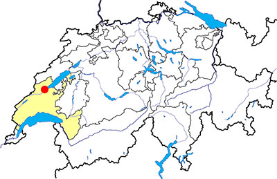
Canton: Vaud
Swiss topographic coordinates: 2'536'118, 1'183'634
Google Earth files:
OpenStreetMap: https://www.openstreetmap.org/node/240130403
Documentation
Bibliography
- D'un mégalithe à l'autre (see Bibliography), pp. 32-35
- Burri-Wyser Elena (dir.), "Stèles ornées, menhirs sculptés et pierres à cupules ; un regard sur les mégalithes vaudois", Archéologie vaudoise, Chroniques 2015, 2016, pp. 44-57
- Weidmann Denis, "Valeyres-sous-Montagny VD, Crusilles-Dessus, Chronique archéologique 2000", Annuaire de la Société suisse de préhistoire et d'archéologie, 84, pp. 275-276
Links
- PressTourism - Escapade sur la route des menhirs: http://www.presstourism.ch/WP_ALEX/?page_id=1028
Other visible sites in the area
- Bonvillars (VD): standing stone
- Chavannes-le-Chêne (VD): Roman quarry
- Grandson (VD): Menhir, medieval city (church, castle, museum)
- Gressy-Sermuz (VD): Celtic oppidum
- Molondin (VD): Medieval village of La Tour Saint-Martin
- Montagny-près-Yverdon (VD): Stone with cupules, medieval castle
- Onnens (VD): Dolmen
- Orbe (VD): Roman villa (mosaics), medieval city (castle, church, city wall, museum)
- Sainte-Croix (VD): Road with ruts, museum
- Ursins (VD): Gallo-Roman temple
- Vuiteboeuf (VD): Castle, medieval tower
- Yverdon-les-Bains (VD): Menhirs, Roman castrum, medieval city (castle, museum)
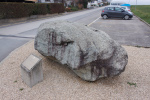
The cupule stone "de Crusilles-Dessus"
Discovered fortuitously in 2000 on the edge of a quarry, the Crusilles-Dessus cupule stone is located next to a public car park, about 200 metres from the discovery site. The exact original location of this stone is not known as it was uncovered during the quarry operation and then set aside along with other blocks of stone too large to be mined. Currently, it is visible at all times, and an information plaque has been installed beside it.
The stone block, made of gneiss, is 3.1 m long, 1.8 m wide and 1.3 m high. Although it bears the marks of modern quarrying, about 25 cups of 4 to 6 cm in diameter can still be seen. The function of these cups is not clearly established (rainwater harvesting? Offering table?). It is possible that this cupule stone is also a menhir statue according to certain signs, such as the western end as a roughly cut base, and the eastern end in the shape of a point that evokes a head.