 Archeoplus
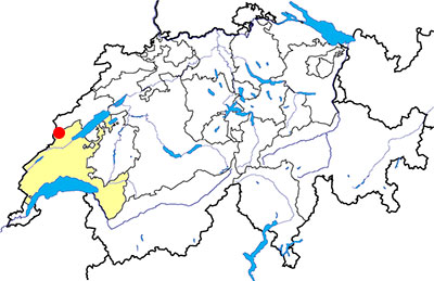
Sainte-Croix (VD)
Documentation
Bibliography
- Berger Ric, Le Nord Vaudois (see Bibliography), pp. 84-89 (castles at Sainte-Croix) and 93-94 (road with ruts)
- Bourgeois Victor-H., Au pied du Jura (see Bibliography), pp. 98-105
- Mottaz François, "De la plaine de l'Orbe en Franche-Compté: voie romaine et chemin saunier", in Archéologie suisse 9, 1986, pp. 124-134
- Le livre à remonter le temps (see Bibliography), p. 148
Links
- Musée des Arts et Sciences de Sainte-Croix: http://www.musee-mas-sainte-croix.ch/index.html
- Via francigena - Wikipedia: http://en.wikipedia.org/wiki/Via_Francigena
- Kulturwege Schweiz: ViaFrancigena – Over the Alps to Rome: http://www.kulturwege-schweiz.ch/en/via-routes/viafrancigena.html
- Kulturwege Schweiz: ViaSalina - On the track of white gold: http://www.kulturwege-schweiz.ch/en/via-routes/viasalina.html
- Flyer Via Salina
Others visibles sites in the area
- Grandson (VD): Menhir, medieval city (church, castle, museum)
- Vuiteboeuf (VD): Castle, medieval tower
- Yverdon-les-Bains (VD): Menhirs, Roman castrum, medieval city (castle, museum)
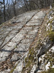
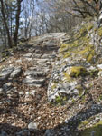
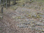
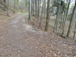
The road with ruts
Nowadays, a road winds steeply upward between Vuiteboeuf and Sainte-Croix. This road cut several times an old road with ruts, considered for a long time as a Roman road (first in Virctor Bourgeois's guidebook, then in Ric Berger's book). In fact, the visible remains are the remains of the road used between the XIVth and the XVIIIth century (see François Mottaz 's article). In the middle of the XVIIIth century, a new road is developed for the use by more vehicles thanks to a more gentle slope and more bends (the medieval road has only one big bend). Nowadays, this road is used for the forestry and has been replaced by the modern road, created in 1838.
The road was part of two importants ways, the Via Francigena and the Via Salina. The Via Francigena was a pilgrim route betwenn Canterbury, in England, and Rome with stages in Reims, Pontarlier, Lausanne and Great St Bernard. The Via Salina was a commercial road for the salt trading betwen France and Bern. During the Middle Ages, two castles were established near the road with ruts. In the way Yverdon - Sainte-Croix, the first one was in the territory of Vuiteboeuf (see the description of The "château des Tours"), and the second one, which have very few visible remains, was at the place of the hamlet called Château de Sainte-Croix. After the village of Sainte-Croix, in the direction of France, there was a third medieval castle, at the so-called place Franc-Castel, where the only visible remains are the ditch in the pastureland.
The ruts are mainly visible in the upper part of the layout of the medieval road. A part of the ruts are newer than 1712, when there was the last main reparation of the road. In the lower part of the layout, some sections are visible as a sunken lane. In 2014, an information pavillion and panels have been set up along the road with ruts.
Swiss topographic coordinates:- Start of the road at Vuiteboeuf: 532'086, 184'642
- Parallel series of ruts: 531'885, 185'085
The musée des Arts et Sciences
Located in the town center of Sainte-Croix, this museum owns an interesting archaeological collection. The objects were discovered at different sites in the area (the Covatannaz gorges, Franc-Castel medieval castle, the Gallo-Roman sanctuary at Le Chasseron).
Swiss topographic coordinates: 528'657, 185'995