 Archeoplus
Pully (VD)

Canton: Vaud
Swiss topographic coordinates: 540'357, 151'230
Google Earth files:
OpenstreetMap: https://www.openstreetmap.org/#map=15/46.5108/6.6679
Documentation
Bibliography
- Collectif, The Roman Villa at Pully and its Wall Paintings, Pully, Archaeological Guides for Switzerland, 2001
- May Castella Catherine (dir.), La villa romaine du Prieuré à Pully et ses peintures murales, Lausanne, Cahiers d'archéologie romande, 2013, 400p.
Links
- Roman villa at Pully: http://www.archeolab.ch
- Patrimoine du Canton de Vaud : Epoque romaine : La villa romaine de Pully: http://www.patrimoine.vd.ch/archeologie/sites-archeologiques/villa-romaine-de-pully/
Others visibles sites in the area
- Lausanne (VD): Menhir, Roman town (forum, sanctuary, houses, barbour, Roman museum at Vidy), medieval city (cathedral, church, city wall), museums
- Lutry (VD): Menhirs, medieval town
- Saint-Saphorin (VD): Roman building, medieval church (archaeological crypt)
- Tour de Gourze (VD): Medieval tower
The Roman villa
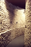
The first remains of the Roman villa have been dug up in 1921-1922 during the restoration of the church. New remains have been found during works in 1943 and in 1951. It is in 1971 that the remains we can see nowadays have been discovered. The importance of this discovery (walls preserved with a height of several metres, mural) encouraged the authorities to protect the remains and to present them to the public. The present museum is open since 1981. Since 2016, the museum is part of the ArchéoLab and is used as a exhibition room. The other part of the ArchéoLab is a space, on the other of the street, where various activies for families and schools are organized.
The first construction step of the villa is during the middle of the first century AD. It is during the second century that the villa is enlarged among others things, with the double hemicycle which is nowadays visible. Then the building is progressively abandoned between the third and the fifth century.
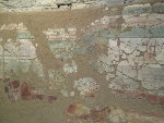
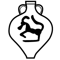
The visible remains are a double hemicycle open in the direction of the lake. The mural was on the inner face of the internal hemicycle. It shows a chariot race on the lower part. The upper part is unfortunately not preserved.
Swiss topographic coordinates: 540'406, 151'209
OpenStreetMap: