 Archeoplus
Bas-Vully (FR)
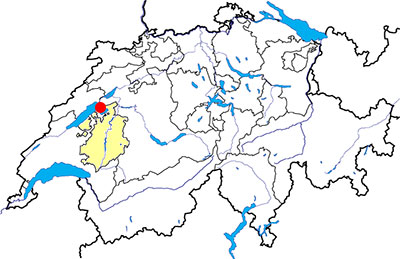
Canton: Fribourg
Swiss topographic coordinates: 574'995, 200'873
Google Earth file: Bas-Vully-en.kmz
Documentation
Bibliography
- Kaenel Gilbert, Curdy Philippe, L'oppidum du Mont Vully, Sugier/Vully, Guides archéologiques de la Suisse 19, 1988
- Kaenel Gilbert, Curdy Philippe, Carrard Frédéric, L'oppidum du Mont Vully, un bilan des recherches 1978-2003, Fribourg, Academic Press Fribourg, 2004
- 100 % Archéologie suisse (see Bibliography), p. 35
Links
- Association Pro Vistaliaco: http://www.provistiliaco.ch/
Others visible sites in the area
- Avenches (VD): Roman city (amphitheatre, theatre, temples, baths, city wall, museum)
- Gletterens (FR): Lakeside village
- Hauterive (NE): Archaeological museum and square
- Vallon (FR): Roman villa (museum, mosaics), medieval church
The Celtic oppidum
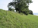
The excavations made between 1978 and 1987 on Mont Vully enabled to recover the remains of a first rampart along the west limit of the plateau called Plan Chatel. According to several clues, the first building step is dated of the final Bronze age (1000-800 BC). Between the second and the first centuries BC, this rampart is rebuilt.
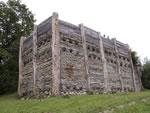
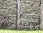
About 120 BC, a second rampart is built to the west of the first one. This second rampart goes across the whole plateau of Mont Vully and protects a surface of 50 hectars. The excavations enabled to recover two gates and at least three towers. About 100 BC, the rampart is repaired, and about 80/70 BC, it is partially destroyed by a probably accidental fire. After that, the site seamed to be abandoned.
Nowadays, the remains of the first rampart are not visible, but it is possible to see the change of incline at its site. The remains of the second rampart are not visible but a section has been rebuilt at the place of the north gate.
Swiss topographic coordinates:
- First rampart: 573'720, 201'416
- Second rampart: 573'605, 201'361