 Archeoplus
Ballaigues (VD)
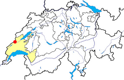
Canton: Vaud
Swiss topographic coordinates: 521'810, 175'903
Google Earth files:
OpenStreetMap: https://www.openstreetmap.org/#map=15/46.7347/6.4176
Documentation
Bibliography
- Mottas François, "De la plaine de l'Orbe en Franche-Compté: voie romaine et chemin saunier", in Archéologie suisse 9, 1986, pp. 124-134
- Naef Albert, Ballaigues (Dt Orbe) Voie romaine déblayée, 1900 (not published, available here)
- Die Schweiz zur Römerzeit (see Bibliography), p. 68
- Les voies romaines, guide romain de voyage (see Bibliography), pp. 31-32
Link
- Bienvenue a Ballaigues (VD) - route romaine: http://www.ballaigues.ch/route_romaine.php
Others visible sites in the area
- Montcherand (VD): medieval church
- Orbe (VD): Roman villa (mosaics), medieval city (castle, church, city wall), museum
- Romainmôtier (VD): Romanesque abbey church
- Vallorbe (VD): Iron museum
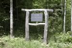
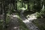
The Roman road
Over the village, it is possible to see the longest Roman road with ruts in Switzerland. The section is visible on approximately 200 meters and the spacing between ruts is about 1.20 meters. The existence of the Roman road in this location is known since the XIXth century, but it is Albert Naef, the first cantonal archaeologist, who makes clear two sections in 1900. It is only in 1971 when there is a real interest for the Roman way, and a request is made for Edgard Pélichet, cantonal archaeologist at this moment, for its development.
The visible section was a part, on one hand, of the road which connected Avenches (Aventicum) with Pontarlier (Abiolica) in France, via Yverdon (Eburodunum) and the Jougne Pass, and on the other hand, the axis Gaul-Italy, on the road Pontarlier-Lausanne-Great St Bernard Pass.
Swiss topographic coordinates: 521'025, 175'911
OpenStreetMap: https://www.openstreetmap.org/way/424479653