 Archeoplus
Lutry (VD)
Canton: Vaud
Swiss topographic coordinates: 542'153, 150'405
Google Earth files:
OpenstreetMap: https://www.openstreetmap.org/#map=16/46.5040/6.6884
Documentation
Bibliography
- Burri-Wyser Elena (dir.), Destins des mégalithes vaudois (see Bibliography)
- Burri-Wyser Elena (dir.), « Stèles ornées, menhirs sculptés et pierres à cupules ; un regard sur les mégalithes vaudois », Archéologie vaudoise, Chroniques 2015, 2016, pp. 44-57
- Masserey Catherine, « Un monument mégalithique sur les rives du Léman », AS, 8, 1985, pp. 2-7
- Voruz Jean-Louis, « Hommes et dieux du Néolithique : les statues-menhirs d’Yverdon », ASSPA, 75, 1992, pp. 37-64
Links
- Commune de Lutry - Menhirs: https://www.lutry.ch/decouvrir-lutry/points-interet-et-evenements/points-dinteret/menhirs/
- Lieux insolites - l’alignement de Lutry: https://www.lieux-insolites.fr/suisse/lutry/lutry.htm
- Patrimoine du canton de Vaud - l’alignement de Lutry: http://www.patrimoine.vd.ch/archeologie/sites-archeologiques/prehistoire-lalignement-de-menhirs-de-lutry/
- ArchéoGallay - Menhirs Lutry: http://www.archeo-gallay.ch/4_07Rhone7.html
- The Megalithic Portal - Lutry: http://www.megalithic.co.uk/article.php?sid=6335958
Other visible sites in the area
- Lausanne (VD): Menhir, Roman town (forum, sanctuary, houses, barbour, Roman museum at Vidy), medieval city (cathedral, church, city wall), museums
- Pully (VD): Roman villa (museum)
- Saint-Saphorin (VD): Roman building, medieval church (archaeological crypt)
- Tour de Gourze (VD): Medieval tower
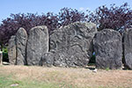
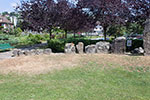
The alignment of menhirs
In 1984, during the summer, during the construction of a public parking lot, the summits of several stony blocks are discovered and the section of cantonal archaeology is alerted. After a first campaign of investigation, an alignment of 24 menhirs is released and archaeological excavations are organized during the autumn for a more thorough study. Afterward, menhirs are taken to allow the construction of the parking lot. In 1986, at the end of the construction work, menhirs are raised on the upper level of the parking lot, with the original orientation, but moved about 30 meters on the West and some meters over the initial height.
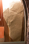
The alignment is formed by an alignment of steles in decreasing order, on both sides of a central stele (the menhir N°6). A menhir (N°24) is known only by the pit in which it was implanted, but it could corresponds to the menhir " du Voisinand ", discovered in 2014 to a hundred meters in the north-east. All the menhirs the summit of which is preserved had been cut with a top rounded off to give a shape of human silhouette. A single menhir (N°14) had engraved decorations. According to a recent study, these decorations were engraved in two phases. A first state gave a feminine aspect with chevrons onto sides (hair) and two encircle halfway up (breast). The second state gave to the menhir a male aspect with eyes, X shaped belt engraved, sheath and three circles halfway up. This menhir is kept in the cantonal museum of history and archaeology in Lausanne, and a copy is visible on-the-spot
The whole monument is dated at the end of the Neolithic (on approximately 2700 BC), but the menhir N°14, in its first state, is older than the rest of the alignment. The monument is frequented till the beginning of the average Bronze Age (approximately 1550 BC).
Swiss topographic coordinates: 542'145, 150'498
OpenStreetMap: https://www.openstreetmap.org/node/266127291