 Archeoplus
Windisch (AG)
Windisch, nowadays part of the outskirts of Brugg, has been a Gaulish oppidum, then a Roman legionary camp at the beginning of the first century AD. First built in wood, then in stonework, this camp is occupied up to 101 AD, and then it is abandoned. It is rebuilt in 260 AD, because of the Germanic invasions, before being definitly abandoned about 400 AD.
The main visible remains are the amphiteatre, several elements of the camp wall, a bath establishment, a part of the aqueduct, and some other buildings of the legionary camp. A part of the discovered objects are shown in the Vindonissa Museum, in Brugg.
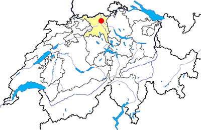
Canton: Aargau
Swiss topographic coordinates: 658'620, 258'777
Google Earth file: Windisch-en.kmz
Old name: Vindonissa
Documentation
Bibliography
- Hartmann Martin, Le camp légionnaire de Vindonissa, Brugg, Guides archéologiques de la Suisse, 1984 (also available in German)
- 100% Archéologie suisse (see Bibliography), p.13
Links
- Vindonissa-Museum: http://www.ag.ch/vindonissa/de/pub/
- Römische Schauplätze: http://www.ag.ch/legionaerspfad/de/pub/roemische_schauplaetze.php
- Gesellschaft Pro Vindonissa: http://www.provindonissa.ch/
Others visible sites in the area
- Baden (AG): Roman town (baths)
- Brugg (AG): Roman castle, museum
- Effingen (AG): Roman road
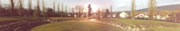
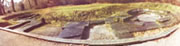
The Roman amphitheatre
The amphitheatre of Vindonissa was the biggest in Switzerland but it is not the best preserved. It stands outside the camp. Built first in wood, its walls were built in stone. Its tiers were in wood, built on a embankment of soil.
Swiss topographic coordinates: 658'410, 258'687
The outer wall
The outer wall of the camp had approximatly a rectangular shape. Nowadays, the only visible remains are the West gate, the North gate and a tower. The South gate has been partially restored.
Swiss topographic coordinates:- West gate: 658'622, 259'084
- North gate: 658'867, 259'439
- Bühlturm: 659'052, 259'421
- South gate: 659'010, 259'054
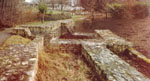
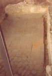
The baths of the mansio
This transport café was composed with two buildings: the inn, with the rooms around a courtyard, and a bath establishment. Nowaday, we can see the baths with its haeted rooms and its pools.
Swiss topographic coordinates: 659'141, 259'342
The Roman aqueduc
The camp was supplied with water by an underground aqueduct built in stonework. A part of this aqueduct is visible in an old people's home.
Swiss topographic coordinates: 658'784, 258'888